


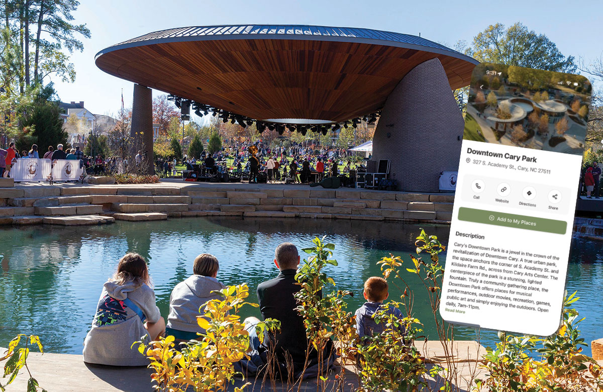
Everyone should have a favorite place to walk, hike, or bike. For some of us, that’s the Neuse River Trail at sunrise. For others, it’s an easy loop where the kids can burn off energy and you get to grab coffee. For Vimal Vyas, the Downtown Cary Park tops the list for “just the different activities that they have there, the openness of it.”
“They have food trucks and it’s so walkable,” he says. “You get a library so (kids) tired of playing on the playground can go look at the books.”
Combining staying active with more leisurely endeavors creates a sweet spot, making it easier to enjoy the outdoors and everything around it.
Now, thanks to a countywide collaboration, those options are combined in one app.

The Wander app combines greenway and park information with nearby restaurants and attraction locations, offering an easy transition from enjoying Gipson Play Plaza at Dix Park to dining downtown afterward.
Seamless Access
Wander is a free, easy-to-use mobile app that combines geographic data, municipal trail information, and commercial listings into one seamless experience. Utilizing open data from an array of local and regional organizations, the app now includes guides and tours for Wake County. With more than 300 miles of greenways and trails, plus over 138,000 acres of open space, there is lots to explore.
The app exists thanks to a partnership between Visit Raleigh (the Greater Raleigh Convention and Visitors Bureau), the Triangle Trails Initiative, Wake County, and participating municipalities such as Cary, Zebulon, Wake Forest, Apex, and Garner. Those partners provide their own data about their parks and trails, which Wander uses to keep maps accurate and up to date. The arrangement helps ensure data accuracy; those managing the assets are the ones updating them.
According to Vimal Vyas, Visit Raleigh’s vice president of data, security, and AI innovation, this partnership is the key to success.
“These are all shared goals of Wake County, all these different municipalities and the parks departments, to bring all this together in one place,” Vimal says. “So I think that’s one of the important parts of this app — to show the connectivity between municipalities and that seamless access and visibility.”
Not every town has the same technology, budget, or staff. Some parks departments have sophisticated GIS systems; others are working with smaller budgets and older tech. Wander helps level the playing field.
“There are different sizes of municipalities, and they all have different technologies, and they all do it differently,” he notes. “But the good thing is, this system gives them the ability to pull it all together.”
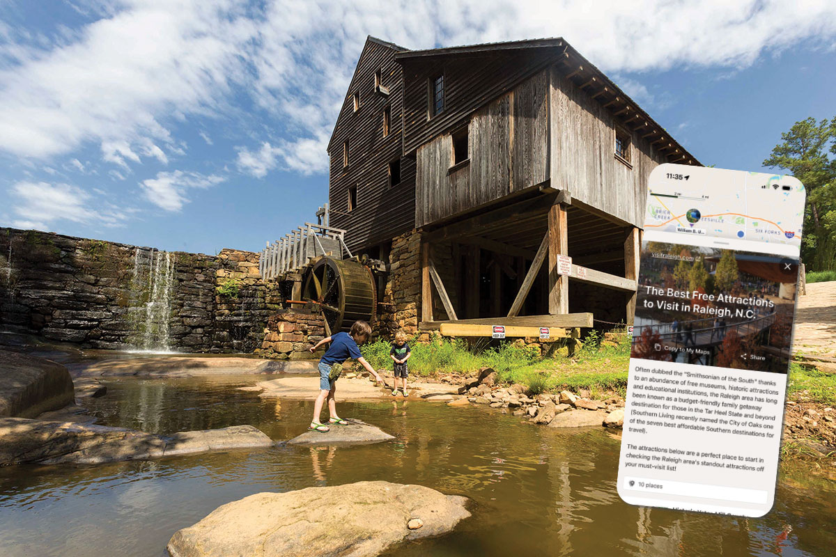
Choose from five curated guides, such as The Best Free Attractions to Visit in Raleigh, which includes Historic Yates Mill County Park.
Setting the Destination
Wander isn’t just a cool tech project — it’s one of the concrete outcomes of Wake County’s long-term tourism roadmap, the Destination Strategic Plan (DSP), sometimes called Destination 2028.
Commissioned in 2017, the DSP is a 10-year tourism plan for Wake County. Visit Raleigh worked with JLL’s Tourism and Destinations team and stakeholders across all 12 municipalities to understand the county’s tourism “ecosystem” and identify priorities that would increase visitor traffic while also improving life for residents.
The plan is organized around eight priorities: Meetings and Conventions, Sports, Events, Key Attractors, Individual Leisure, Destination Development, Regional Demand Drivers, and Quality of Place. Wander fits squarely in Quality of Place, representing the assets that residents already love — parks, trails, greenways, museums, walkable downtowns — and finds ways to position them for visitors, too. The strategic plan isn’t simply for bringing more guests; it prioritizes smarter investments in the things that make Wake County a great place to live.
By centralizing trail and park information and tying it to local businesses and attractions, Wander turns a strategic goal — elevating Quality of Place — into a tool you can download and use this weekend.
Promoting discovery — of new parks, trails, and attractions — is a key goal of Visit Raleigh’s collaboration with Wander.
Built for Real-Life Needs
Vimal appreciates that Wander solves a very real family problem: what to do after the playground or hike.
“My experience in going out with my family (is asking), what is around? What is there to do? What’s close by?” he explains. “Once the kids are tired at the park, they want ice cream; they want to get a drink. What’s nearby? Is there a coffee shop? Is there a bakery?”
Wander lets you see that full picture — trail plus treats, playground plus lunch, bike ride plus brewery — without bouncing between multiple apps and websites. Because Visit Raleigh maintains a robust database of hospitality partners, and municipalities contribute their trail data, Wander can “snap” those pieces together.
“I think that’s the biggest part: We want to enhance the quality of life for the residents, but also create more experiences for the visitors,” Vimal says. At the same time, centralizing all this data “gives visibility to other areas, increasing tourism regionally.”
This is a tremendous benefit to the area. Wake County already sees 19 million visitors each year, spending $3.4 billion and supporting 26,000 local jobs. Those guests also generate $321 million in state and local tax revenue. Using the app to increase these numbers — even marginally — can have a huge benefit for local residents.
You can also take the app on the road. In addition to Wake County, the Wander app includes curated lists for destinations like Chatham and Washington counties as well as Statesville, Edenton, and other locations in South Carolina and Virginia. And if you’re planning a trip for spring break or summertime, consider perusing Wander for other, more distant paths to roam.

The expansive Outdoor Mural Trail highlights 37 works of public art around Wake County, including the All Aboard mural in Cary.
The Road Ahead
Wander is already a great resource, but that doesn’t mean Visit Raleigh and its partners are done.
These preset tours provide fun options for exploring the area with the planning already done!
Favorite Fall Hikes in Raleigh with 5 locations
The Best Free Attractions to Visit in Raleigh with 10 places
Outdoor Mural Trail with 37 places
Seven Outdoor Wonders of the Raleigh Area
36 Hours in Raleigh with 26 items that will probably be tough to complete in 36 hours!
“We will be adding check-in processes, gamifying the platform,” Vimal shares. He points to existing efforts like Visit Raleigh’s Mural Trail, which includes 37 examples of the area’s outdoor art, as the kind of challenge to enjoy. More check-ins, challenges, and incentives for visiting certain parks or completing specific trails are in the works.
In the end, the Wander app is about discovery. Maybe your favorite trail is one you already know by heart. But it may just be that your favorite hike — the one your kids remember, the one you recommend to visiting friends, the one that makes you feel lucky to live in Wake County — is one you haven’t found yet.
- Find Your Next Favorite Trail with Wander
- Out & About in Wake County: March/April 2026
- Pay it Forward: United Arts Wake County
- Small Business Spotlight: TrenLend
- 2026 Maggy Awards
- 2026 Maggy Awards: Restaurants
- 2026 Maggy Awards: Lifestyle
- 2026 Maggy Awards: Services
- 2026 Maggy Awards: Shopping
- Game On!
- Garden Adventurer: Voodoo Gardening